
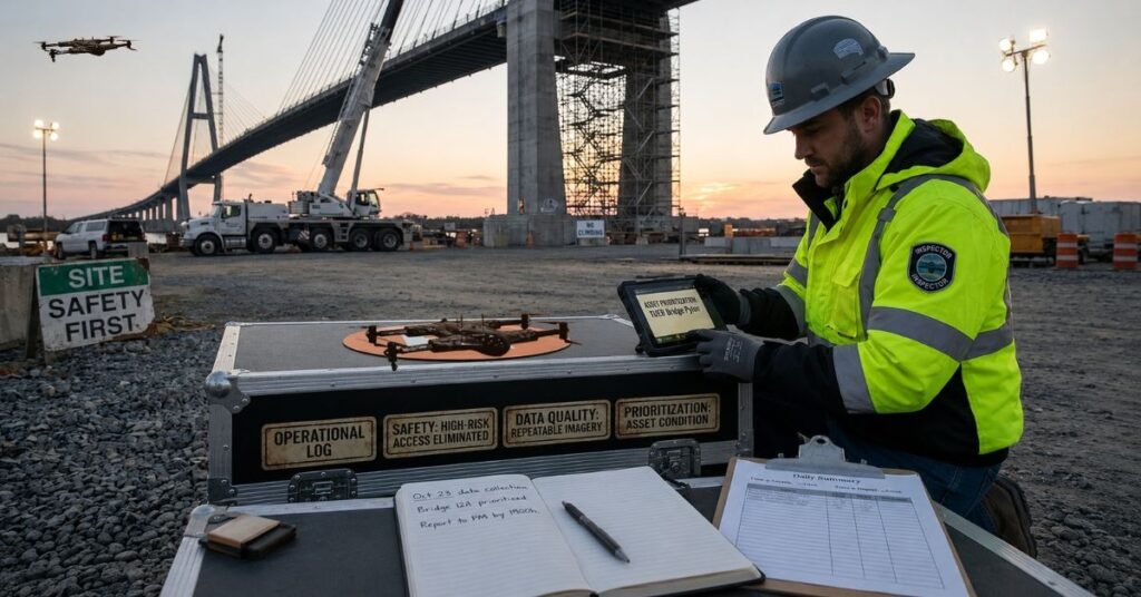
For decades, inspecting bridges, towers, pipelines, and large buildings meant sending crews into environments that were, at best, uncomfortable and, at worst, genuinely hazardous. Workers suspended from scaffolding over rushing water. Technicians climbing communication towers in poor weather. Entire teams spending days on-site to collect data that would take weeks to properly analyze.
The cost in time, labor, and human risk was simply accepted as the price of doing business.
That calculation has changed. Drone infrastructure inspection has moved from experimental concept to standard operating procedure across a growing number of industries—and the organizations still on the fence are finding it harder to justify the delay.
The Problem: Infrastructure Is Aging Faster Than We Can Inspect It
Maintenance backlogs are a reality in nearly every asset-heavy sector. Roads, bridges, utility networks, and commercial buildings built decades ago are reaching — or already exceeding — their intended service lives, while drone infrastructure inspection teams remain stretched thin and budgets stay flat.
The core challenge isn’t just access. It’s scale.
Manual surveys are
- Slow: a single bridge inspection can take days with traditional methods
- Inconsistent: results depend heavily on individual inspector judgment
- Infrequent: high costs push organizations toward wider inspection intervals
- Risky: confined spaces, heights, and live traffic create real exposure for field crews
The result is that infrastructure monitoring becomes reactive. Teams respond to failures rather than preventing them, and reactive maintenance is almost always more expensive.
Current Technologies Changing the Game
AI-Powered Aerial Surveys
Today’s AI-powered inspection drones are far beyond basic camera platforms. They combine multiple sensing technologies into a single airborne unit:
| Technology | What It Detects |
| Thermal Imaging | Moisture intrusion, heat loss, electrical faults |
| LiDAR Sensors | Structural deformation, geometry mapping |
| Computer Vision | Cracks, corrosion, surface degradation |
| RGB / 4K Camera | Visual documentation, facade detail |
This multi-sensor approach means a single flight can generate richer, more actionable data than a multi-day manual survey—and do it without putting anyone at risk.
Bridge Inspection Technology Gets Smarter
Bridge inspection technology has been one of the fastest-evolving segments in civil infrastructure. Drone-based assessments are now routinely used for:
- Underbridge and deck inspections without lane closures
- Post-event rapid assessments (floods, earthquakes, heavy impact)
- Detecting rebar corrosion beneath concrete surfaces using thermal imaging
- Creating 3D structural models for engineering review
Some infrastructure agencies are already moving toward semi-permanent drone stations near critical crossings — units that can be remotely activated within minutes of a weather event or structural alert.
Building Inspection Drones for Urban Environments
Building inspection drones have become particularly valuable in dense urban settings where scaffolding is costly, disruptive, and sometimes simply impractical. Facade audits, roof condition assessments, and window seal evaluations that once required rope access teams can now be completed in hours.
For property managers overseeing large commercial portfolios, that time savings compounds quickly across a full asset register.
Why Organizations Are Making the Switch
The operational case for aerial inspection solutions goes beyond cost savings — though those are real. Here’s what infrastructure teams consistently report after adopting drone-based programs:
- Fewer safety incidents — personnel stay out of high-risk access situations
- Better data quality — consistent, repeatable imagery builds reliable historical records
- Higher inspection frequency—lower cost per survey means more touchpoints per asset
- Faster reporting—digital outputs go from flight to analysis to decision in hours, not weeks
- Smarter prioritization — standardized data makes it easier to rank assets by condition
Organizations evaluating how to structure their aerial programs often look for an autonomous drone inspection platform capable of handling varied mission profiles—from close-range structural surveys to wide-area mapping assignments—without requiring a separate system for each use case.
What’s Coming Next in Drone Infrastructure Inspection
The next wave isn’t just about better hardware. It’s about integration.
Where the industry is heading:
- Autonomous repeat missions — instead of dispatching crews on fixed schedules, drones run pre-programmed routes, push data automatically, and surface flagged anomalies for human review. The crew’s role shifts from collecting data to acting on it
- Live asset management feeds—infrastructure monitoring platforms are beginning to pull drone data directly into maintenance workflows, cutting out the manual reporting layer that slows everything down
- Predictive maintenance models — AI inspection drones that stack current scan results against historical baselines, giving teams a rough sense of when something will need attention, not just whether it does
- Regulatory expansion — BVLOS frameworks are slowly maturing across several regions, which matters more than people realize. It removes one of the last practical barriers to scaling aerial inspection solutions in remote corridors and dense urban environments
Building inspection drones in particular are being pulled into broader smart building conversations—where findings feed into energy audits, capital planning, and insurance assessments, not just the maintenance queue.
The Bottom Line
Drone infrastructure inspection isn’t a technology trend in search of a use case. It’s a direct response to real operational pressures — aging assets, workforce constraints, shrinking margins, and rising accountability standards — that aren’t going away anytime soon.
The organizations seeing the strongest results aren’t treating drones as a replacement for everything else. They’re using aerial inspection solutions, including advanced platforms from ZenaDrone, as a force multiplier — getting more coverage, better data, and faster decisions from the teams they already have.
In construction, utilities, public safety, and asset management alike, the direction is clear. The only real variable is how quickly each organization chooses to move.